New tool enables navigation with electronic charts
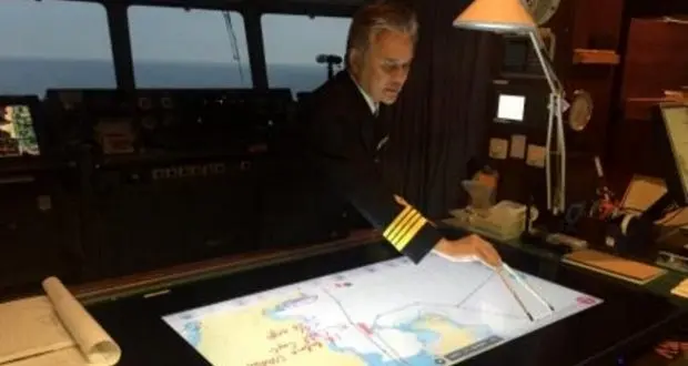
TIN news: Nippon Yusen Kabushiki Kaisha (NYK), the Monohakobi Technology Institute and Japan Radio Co. Ltd. (JRC) have jointly developed a support tool for officers to better manage and share navigational information.
As the company explains, the use of ECDIS, which is mandatory from under IMO, does not allow additional navigational information to be written by hand, as can easily be done on a conventional paper chart. J-Marine NeCST addresses that problem by including a function that lets users write directly on electronic charts.
In addition, the tool also integrates meteorological and hydrographical forecasts for the preparation of optimal route plans. The chart on display can be overlapped with weather information.
Moreover, electronic maps and data can be promptly integrated and shared among ships and land, making J-Marine NeCST a complementary tool to the ECDIS.
Apart from these, the tool can easily be customized and expanded to meet the individual needs of users.


![AIRBUS A380 [MORE THAN 600 PASSENGER’S CAPACITY PLANE]](https://cdn.tinn.ir/thumbnail/4jCp4EQvCU0b/IjHVrSYQrIAqIzXuTzADR7qLYX4idQT4nfq__26E5SCUPLMqfhWkWajvuO9Wfq1ql1TjV4dhkrHliNQU82kMpo2NNftT_NGEwHc9KXtN_rk731bmifa2IQ,,/airbus-a380-structure1.jpg)

Send Comment