|
Code:
132091
|
AMSA: How to identify official nautical charts
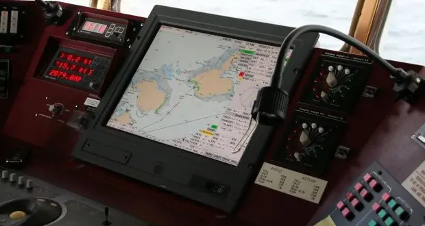
The Australian Maritime Safety Authority (AMSA) issued a marine notice, in order to draw attention to the importance of using only official nautical charts to comply with flag State requirements, under Chapter V of the amended International Convention for the Safety of Life at Sea (SOLAS).
As AMSA continues to witness the use of unofficial paper and electronic nautical charts on board ships, it outlines that official charts are those issued by or on the authority of a government, authorised hydrographic office or other relevant government institution.
AMSA notes that for an Electronic Navigational Chart (ENC) or paper nautical chart to be considered adequate for navigational purposes, it must be:
- issued officially
- of appropriate scale, suitable for the navigational task at hand
- of the latest edition
- used in its original form, and
- maintained up-to-date, using the latest available notices to mariners or ENC update service
On the other hand, unofficial paper charts include (but are not limited) to:
- photocopies
- facsimiles or imitations of official paper charts
- large format commercial printed copies of scanned ENC, and
- paper charts ‘assembled’ by printing several small portions of a Raster Navigational Chart (RNC)
Recommendations
- AMSA urges ship owners, operators, agents and masters to contact AHS, if they suspect that an ‘AUS’ paper chart or an ‘AU’ ENC is not genuine, and provide relevant details. AHS will actively seek to stop the production and sale of unofficial copies of AHS products.
- AMSA also reminds that the carriage of up-todate nautical charts is critical to the safety of navigation, so it urges all purchasers, users, marine surveyors and recognised organisations to be vigilant in identifying unofficial nautical charts.
Detailed information may be found by reading the full notice:


![AIRBUS A380 [MORE THAN 600 PASSENGER’S CAPACITY PLANE]](https://cdn.tinn.ir/thumbnail/4jCp4EQvCU0b/IjHVrSYQrIAqIzXuTzADR7qLYX4idQT4nfq__26E5SCUPLMqfhWkWajvuO9Wfq1ql1TjV4dhkrHliNQU82kMpo2NNftT_NGEwHc9KXtN_rk731bmifa2IQ,,/airbus-a380-structure1.jpg)

Send Comment