UK Hydrographic Office participates to autonomous navigation research
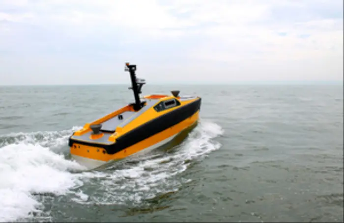
The UK Hydrographic Office (UKHO) has contributed to a new UK government-funded study on navigational requirements for autonomous maritime vessels to identify the future data requirements for autonomous shipping, and explore how navigational and wider geospatial data can be used to enable the safe navigation of smart and unmanned autonomous vessels.
The UK Hydrographic Office (UKHO) has contributed to a new UK government-funded study on navigational requirements for autonomous maritime vessels to identify the future data requirements for autonomous shipping, and explore how navigational and wider geospatial data can be used to enable the safe navigation of smart and unmanned autonomous vessels.
Namely, the partnership is between UKHO, L3 ASV and the Maritime and Coastguard Agency (MCA).
The study began by exploring the features already existent navigational data and charts in terms of what they comprise, their structure and how they are updated.
Then, it examined a way on how these data could be repurposed to develop a ‘Smart Chart’ system, which will combine data such as radio signals, regulations, tides and foundation navigational data, that can be interpreted by a computer without the use of an onboard crew.
Moreover, Mark Casey, Head of Research, Innovation and Integration at the UKHO noted that the marine geospatial data combine bathymetry depicting the seafloor to the speed and direction of the tides, supports navigation across our oceans.
Nusrat Ghani, UK Shipping Minister, addressed that technology will keep on altering the UK’s world-leading maritime sector through the years. As he stated, technologies such as Smart Charts and Smart Shipping will enhance maritime industry.
As Ghani noted, technology and innovation are a key part of the Maritime 2050 initiative, which will set a vision for the growth and success of the Scottish maritime sector over the next 30 years.
Finally, Dan Hook, Senior Director of Business Development, L3 ASV, commented that the existing navigational data and charts belong to the past. In the future, many vessels will navigate without the help of the human element and charts will be read by computers.


![AIRBUS A380 [MORE THAN 600 PASSENGER’S CAPACITY PLANE]](https://cdn.tinn.ir/thumbnail/4jCp4EQvCU0b/IjHVrSYQrIAqIzXuTzADR7qLYX4idQT4nfq__26E5SCUPLMqfhWkWajvuO9Wfq1ql1TjV4dhkrHliNQU82kMpo2NNftT_NGEwHc9KXtN_rk731bmifa2IQ,,/airbus-a380-structure1.jpg)

Send Comment