|
Code:
77805
|
USCG cooperation ensuring mariner safety
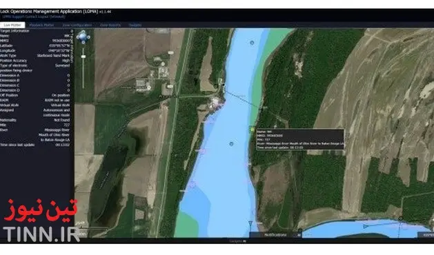
TIN news: Across the nation, more than 48,000 Coast Guard aids to navigation, commonly known as ATON, mark every navigable waterway, identifying navigational hazards and ensuring mariner safety. But what happens when navigational aids are knocked off course by a natural disaster like a hurricane or flood? This recently happened during flooding on the Mississippi River. In mid-December, a tow vessel William Strait sank in 20 feet of water on the lower Mississippi River following a collision with the tow vessel Margaret Ann.
Excessive flooding kept the Coast Guard from placing a floating navigational aid, so the Coast Guard, in partnership with the U.S. Army Corps of Engineers, leveraged technology and quickly established a virtual aid to navigation to mark the sunken wreck until the flood waters recede enough for it to be salvaged.
Broadcasted via Automatic Identification System, or AIS, the virtual aid transmits a constant bearing and range that can be seen on AIS integrated electronic charting systems and radars.
“The virtual aid was another step forward in the analog-to-digital transformation of U.S. waterways,” said Capt. Scott J. Smith, the chief of the Coast Guard Office of Navigation Systems.
“Together with federal, state and local partners and industry stakeholders around the nation, the Coast Guard is working to increase situational awareness and navigational safety on U.S. waterways.”
The Coast Guard Office of Navigation Systems and Eighth Coast Guard District Waterways Management Office worked with the Lock Operations Management Team, LOMA, from the Coastal and Hydraulics Laboratory, CHL, at the Army Corps of Engineers Research and Development Center to establish the virtual aid.
The Army Corps of Engineers LOMA team included employees from CHL and the Information Technology Laboratory.
Employees from the Army Corps of Engineers-Information Technology Operations and Security Departments, U.S. Army Corps of Engineers Memphis District, Corps Marine Maintenance Facility at Ensely Engineer Yard, and the Coast Guard’s Research and Development Center took part in the effort.
“The multiagency collaboration on e-Navigation and AIS began over 10 years ago, and in 17 years of federal service, it has be one of the most successful partnerships in which I have had the pleasure to work,” said Michael F. Winkler, a research hydraulic engineer at CHL.
“The effort to have a virtual ATON mark the sunken vessel went from general discussion to successful transmission in just over 48 hours.”
Some of the U.S. Coast Guard’s AIS initiatives have included sending transmissions from a portable AIS unit to mark ATON and hazards in a waterway in support of the “Digital Lightship Resiliency Project” on the Coast Guard Cutter Healy and using AIS to mark the abutments on the San Francisco-Oakland Bay Bridge to improve bridge conspicuity.
“These initiatives will increase the reliability, availability, resiliency and effectiveness of the ATON system, while simultaneously improving mariner situational awareness,” said Cmdr. John M. Stone, the chief of the Coast Guard Navigation Technology and Risk Management Division.
Excessive flooding kept the Coast Guard from placing a floating navigational aid, so the Coast Guard, in partnership with the U.S. Army Corps of Engineers, leveraged technology and quickly established a virtual aid to navigation to mark the sunken wreck until the flood waters recede enough for it to be salvaged.
Broadcasted via Automatic Identification System, or AIS, the virtual aid transmits a constant bearing and range that can be seen on AIS integrated electronic charting systems and radars.
“The virtual aid was another step forward in the analog-to-digital transformation of U.S. waterways,” said Capt. Scott J. Smith, the chief of the Coast Guard Office of Navigation Systems.
“Together with federal, state and local partners and industry stakeholders around the nation, the Coast Guard is working to increase situational awareness and navigational safety on U.S. waterways.”
The Coast Guard Office of Navigation Systems and Eighth Coast Guard District Waterways Management Office worked with the Lock Operations Management Team, LOMA, from the Coastal and Hydraulics Laboratory, CHL, at the Army Corps of Engineers Research and Development Center to establish the virtual aid.
The Army Corps of Engineers LOMA team included employees from CHL and the Information Technology Laboratory.
Employees from the Army Corps of Engineers-Information Technology Operations and Security Departments, U.S. Army Corps of Engineers Memphis District, Corps Marine Maintenance Facility at Ensely Engineer Yard, and the Coast Guard’s Research and Development Center took part in the effort.
“The multiagency collaboration on e-Navigation and AIS began over 10 years ago, and in 17 years of federal service, it has be one of the most successful partnerships in which I have had the pleasure to work,” said Michael F. Winkler, a research hydraulic engineer at CHL.
“The effort to have a virtual ATON mark the sunken vessel went from general discussion to successful transmission in just over 48 hours.”
Most commercial vessels operating on U.S. waters are required to use AIS technology by March 1, 2016. To access the increased navigation and marine safety information, the Coast Guard encourages all mariners to equip their vessels with electronic charting systems that display AIS transmissions.
“These initiatives will increase the reliability, availability, resiliency and effectiveness of the ATON system, while simultaneously improving mariner situational awareness,” said Cmdr. John M. Stone, the chief of the Coast Guard Navigation Technology and Risk Management Division.


![AIRBUS A380 [MORE THAN 600 PASSENGER’S CAPACITY PLANE]](https://cdn.tinn.ir/thumbnail/4jCp4EQvCU0b/IjHVrSYQrIAqIzXuTzADR7qLYX4idQT4nfq__26E5SCUPLMqfhWkWajvuO9Wfq1ql1TjV4dhkrHliNQU82kMpo2NNftT_NGEwHc9KXtN_rk731bmifa2IQ,,/airbus-a380-structure1.jpg)

Send Comment